Paleolithic Dmanisi
GEOLOGY
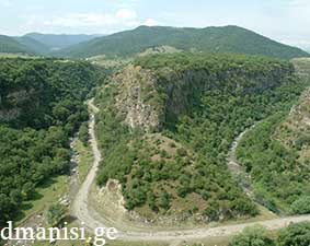
The Lower Paleolithic site of Dmanisi is situated beneath the ruins of the medieval town of Dmanisi, which occupies the promontory [fig. to the left] overlooking the confluence of the Mashavera and Pinezauri rivers, about 100 meters below. The base of the promontory is comprised of Late Cretaceous volcanogenic sedimentary rocks. About 1.85 million years ago, a basaltic lava flowed down the Mashavera river valley and one of its spurs turned around the promontory into the smaller Pinezauri valley, where the basalt formed a natural dam that gave rise to the temporary lake along the former Pinezauri course. Later, the two rivers created the gorges and the modern day promontory. However, geomorphological, sedimentary and geochemical data reveal that none of the Dmanisi sediments are lacustrine, and in fact, the ephemeral lake stood approximately 25 meters below the Dmanisi Plio-Pleistocene occupation site.
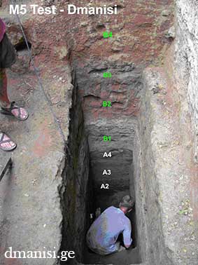
The sediments at Dmanisi overlie the uneroded Mashavera basalt, which is dated by Argon/Argon to 1.85 million years ago. The sedimentary stratigraphy of Dmanisi is divided into two main units A and B, which are each comprised of several sub-layers [fig. to the right]. Stratum A is the latest Olduvai, after which we have the paleomagnetic reversal 1.78 million years ago and Stratum B – earliest Matuyama. The lower layer of the stratum B contains a calcareous soil formation with penecontemporaneous precipitation of subsurface groundwater calceretes of 30-40 cm thickness, enveloping buried geologic contacts and higher parts of Mashavera basalt. These calcretes provide a critical geochronological control over the stratigraphy of the site and the preservations of the lowest layers.
Volcanic ashes of the stratum A covered the basalt quickly, and contain stone artifacts. Stratum B ashes were quickly deposited, burying human fossils along with thousands of animal bones and artifacts. The complete sedimentation of the site took less than 10000 years.
Below is the grpahical representation of the Block 2 stratigraphy:
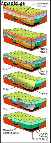
6. calcareous soil formation in B2b deposits, with penecontemporaneous precipitation of subsurface groundwater calcretes enveloping buried geologic contacts and higher parts of Mashavera Basalt;
5. episodic ashfalls accumulate as Stratum B2, with stratified occupation surfaces;
4. deposition of B1x sediment, with artifacts, faunas and hominin fossils D2700, D2735; B1a ashfall deposits veneer site, followed by erosion and filling of B1z gully;
3. formation of gullies along axis of collapsed pipe, and accumulation of Stratum B1y (reverse polarity, as for all subsequent sediments at site) with bones, artifacts and hominin fossils D3444, D3900, D2600;
2. piping of A deposits with breaching to surface;
1. deposition of Strata A1-A2 ashes (1.81 Ma, normal polarity) on the uneroded Mashavera Basalt (1.85 Ma, normal polarity).
Photograph of M5 stratigraphy and graphical representation of Block 2 by Reid Ferring

dmanisi.ge © 2013